


FSA Livestock Forage Disaster Program Eligibility, Derived
This repository recomputes eligibility for the USDA Livestock Forage Disaster Program (LFP) from the US Drought Monitor and FSA’s published Normal Grazing Periods, for program years 2008 onward, under four different conventions for aggregating the drought monitor to counties.
The US Drought Monitor is drawn without regard to political boundaries, so it must be cut to county shapes before the eligibility rule can be applied. The boundary dataset used for that cut is not specified in statute and FSA does not publish it. This archive reports what the rule yields under each convention, so the sensitivity of eligibility to that choice can be measured.
📂 View the LFP eligibility reanalysis archive listing here.
Note: This archive is derived, not a record of USDA’s determinations. For FSA’s own published eligibility determinations, see sustainable-fsa/fsa-lfp-eligibility. The two are not expected to agree everywhere, and where they differ this archive is not the authority.
🗂️ Contents
fsa-lfp-eligibility-derived.csv— every qualifying drought event, its date, and the drought factor it earnsfsa-lfp-eligibility-derived.parquet— the same records as Parquetfsa-lfp-eligibility-derived.json— the same records restructured for browsers (see Output Data)usdm.parquet— the weekly county USDM record this archive reads, all four aggregations side by sideqa-report.txt— validation summary, and the enumerated list of every record affected by the FSA-county/Census-county fan-outdata/usdm/— the same weekly record as immutable per-week filesfsa-lfp-eligibility-derived.R— processing script_manifest.txt— flat index of every file in the S3-hosted mirror
☁️ Archive Hosting & Automated Publishing
The combined outputs, the QA report, and the weekly files under
data/usdm/ are mirrored to S3 and served via CloudFront at
https://data.sustainable-fsa.com/fsa-lfp-eligibility-derived/ (browse
the archive
listing
or
_manifest.txt
for a flat index).
The derived records are mirrored in both places: the CSV, Parquet,
and JSON are committed to this repository as well as published to S3, so
the archive is readable from a git checkout alone and its history is
inspectable commit by commit. The weekly USDM inputs under data/usdm/
and the combined usdm.parquet are far larger and live on S3 only.
Publishing is handled by
fsa-lfp-eligibility-derived.R via
the shared R/s3-archive.R helpers, and runs
automatically in GitHub Actions
(.github/workflows/fsa-lfp-eligibility-derived.yaml).
It is dispatched each Thursday once the upstream USDM county
aggregations have published, with a cron fallback. The workflow
authenticates to AWS via GitHub OIDC (no long-lived credentials stored
in the repo), re-renders this README from the freshly updated archive,
and commits it back to git only if the rendered output changed.
The weekly build is incremental: a USDM week already present in
data/usdm/ is never recomputed, and a week not yet published by all
four upstream aggregations is skipped rather than half-built.
📥 Input Data
Everything is read over HTTPS from companion archives in this organization. No FOIA workbook is read directly, and no county boundary is recomputed here.
USDM county aggregations
Four archives, each aggregating the same weekly USDM polygons to counties under a different boundary convention. For every county and week, this archive takes the worst drought class touching the county, which is the standard the statute sets — 7 U.S.C. § 1531(d)(3) triggers on drought “in any area of the county”.
| Archive | Boundary convention |
|---|---|
usdm-counties-reported |
The county statistics NDMC itself reports |
usdm-counties-fsa-lfp |
The boundary file FSA uses for LFP |
usdm-counties-census-2020 |
Census 2020 counties, held fixed |
usdm-counties |
Census counties, vintage-matched to each USDM week |
Normal Grazing Periods
fsa-normal-grazing-period
— the start and end date of the normal grazing period for each program
year, FSA county, and pasture type, obtained by FOIA. This defines the
window inside which drought counts.
FSA county definitions
fsa-counties-dd22 —
the FSA county to Census county (FIPS) crosswalk.
The dd22 vintage is used for every program year rather than
vintage-matched against dd17. It resolves every FSA county the Normal
Grazing Period archive names, where dd17 drops Shoshone County, ID
(16079) from 2015 on, and holding one crosswalk fixed keeps the
vintage from becoming a year-dependent confound in the comparison across
aggregations.
🧹 Processing Workflow
The processing script
fsa-lfp-eligibility-derived.R:
- Downloads each newly published week from all four USDM county
aggregations, takes the worst class per county, and writes one
Parquet file per week to
data/usdm/. - Combines those weeks into
usdm.parquet. - Reads the Normal Grazing Periods and maps them from FSA counties onto Census counties through the dd22 crosswalk, keeping both keys (see Two county keys below).
- Run-length encodes the weekly county USDM record into runs of
constant drought class, collapsing everything below D2 into a single
< D2class since nothing below D2 can qualify. - Clips each run to the normal grazing period. Only the portion of a drought spell falling inside the grazing window counts toward a tier.
- Dates each qualifying drought event under the rules in force for that program year, and assigns the drought factor it earns.
- Keeps the escalating events. Within each county, program year, and pasture type, a record is kept only when it raises the drought factor above everything that came before it, so the archive reads as the eligibility history actually accrued over the grazing season.
- Validates the result and writes a QA report.
- Exports
fsa-lfp-eligibility-derived.csv,fsa-lfp-eligibility-derived.parquet, and the browser-optimizedfsa-lfp-eligibility-derived.json, and publishes to S3.
📤 Output Data
fsa-lfp-eligibility-derived.csv and .parquet
Identical records in both formats. One record per Census county, FSA county, USDM county aggregation, program year, pasture type, and qualifying drought event. A county with an escalating drought season carries several records — one for each tier as it was reached.
Prefer the Parquet where you can. It carries types, so FIPS and
FSA County come back as character and Qualifying Date as a date. The
CSV carries none, and what you get depends on the reader:
readr::read_csv() infers both correctly, but base R’s read.csv() and
pandas read the county codes as integers and drop the leading zero,
turning Autauga County, AL (01001) into 1001. Read them as character
explicitly:
readr::read_csv(
  "https://data.sustainable-fsa.com/fsa-lfp-eligibility-derived/fsa-lfp-eligibility-derived.csv",
  col_types = readr::cols(FIPS = "c", `FSA County` = "c")
)
| Variable | Description |
|---|---|
FIPS |
Census county (5-digit state + county ANSI/FIPS code) |
FSA County |
FSA county (5-digit FSA state + county code) |
source |
Which USDM county aggregation produced this record |
Program Year |
LFP program year |
Pasture Type |
Grazing land or pastureland type, as FSA classifies it |
Qualifying Drought Event |
The tier reached: D2, D3a, D3b, D4a, D4b, or for 2026 onward D2a_2026 and D2b_2026 |
Qualifying Date |
The date the tier was satisfied — the last day of the qualifying window |
Drought Factor |
Monthly payments the event earns |
Drought Factor is not the payable amount. It corresponds to FSA’s
Drought Factor, not its Payment Factor. FSA caps an award at the
Maximum Eligible Payment Months implied by the length of the grazing
period, so the payable figure is min(Drought Factor, MEPM). This
archive carries neither the cap nor the capped figure, because both
follow from the grazing period alone — take the dates from
fsa-normal-grazing-period
and apply whatever cap your analysis calls for.
fsa-lfp-eligibility-derived.json
fsa-lfp-eligibility-derived.json
holds the same records as the CSV and Parquet — derived from the
identical validated table in the same run — restructured for direct use
in a browser. It is what the eligibility dashboard loads, not an
archive-of-record format; for analysis, use the CSV or Parquet. It
differs in structure, not content:
- Column-oriented: one array per field with one entry per record, rather than one object per record, sorted on the integer index columns so the file gzips from ~11.7 MB to roughly 350 KB over the wire.
- Dictionary-coded strings: the 15 pasture types, 2,896 FSA county codes, 2,968 Census FIPS codes, 7 qualifying drought events, and 4 USDM county aggregations each appear once in a lookup array; the record arrays hold integer indices into them.
- Compact dates: each
Qualifying Dateis a day-of-year (qy) plus a year offset from the program year (qo), not an ISO string. A grazing season that opens in the calendar year before its program year carries qualifying dates there too — 12% of the events here — so the offset is what makes the day number unambiguous.
The payload is keyed on the FSA county code, with the Census FIPS
code carried as a parallel per-record dictionary — the same two keys the
tabular files carry, for the same reason (see Two county keys below).
It also carries the source dimension, so every record names which of
the four USDM county-aggregation conventions produced it and all four
reanalyses are readable from the one file. There are no nulls anywhere:
every field is populated for every record, which the run asserts before
writing.
There are no payment columns. Drought Factor is not the payable
amount, and neither the
Maximum Eligible Payment Months cap nor the capped figure is in this
archive in any format.
The payload is self-describing via its schema field
(fsa-lfp-eligibility/1), a frozen contract with the dashboard: fields
may be added, but existing ones are never renamed or reordered without
bumping the schema. The layout is shared with
fsa-lfp-eligibility
and
fsa-lfp-eligibility-web,
so the three archives can be compared directly; the dataset field says
which one a payload came from.
usdm.parquet
The weekly county USDM record this archive reads. One row per Census county and USDM week, with one column per aggregation carrying that week’s worst drought class in that county.
| Variable | Description |
|---|---|
FIPS |
Census county (5-digit state + county ANSI/FIPS code) |
usdm_date |
USDM map date (the Tuesday the map takes effect) |
usdm-counties |
Worst class that week, vintage-matched Census aggregation |
usdm-counties-census-2020 |
Worst class that week, Census 2020 aggregation |
usdm-counties-fsa-lfp |
Worst class that week, FSA LFP boundary aggregation |
usdm-counties-reported |
Worst class that week, NDMC-reported aggregation |
Drought classes are ordered factors: None < D0 < D1 < D2 <
D3 < D4.
🌵 Drought tiers and payment ladders
LFP pays for grazing losses when the US Drought Monitor rates a county at a qualifying intensity during the normal grazing period for that pasture type. The tiers, and the monthly payments they earn, have changed twice.
2008 Farm Bill — program years 2008–2011
| Monthly payments | Qualifying drought event |
|---|---|
| 1 | D2 for at least 8 consecutive weeks |
| 2 | D3 at any time |
| 3 | D3 for at least 4 weeks, or D4 at any time |
2014 Farm Bill — program years 2012–2025
| Monthly payments | Qualifying drought event |
|---|---|
| 1 | D2 for at least 8 consecutive weeks |
| 3 | D3 at any time |
| 4 | D3 for at least 4 weeks, or D4 at any time |
| 5 | D4 for at least 4 weeks |
P.L. 119-21 — program years 2026 onward
| Monthly payments | Qualifying drought event |
|---|---|
| 1 | D2 for at least 4 consecutive weeks |
| 2 | D2 for at least 7 of the previous 8 consecutive weeks |
| 3 | D3 at any time |
| 4 | D3 for at least 4 weeks, or D4 at any time |
| 5 | D4 for at least 4 weeks |
Section 10401(b) of P.L. 119-21 (July 4, 2025) split the D2 tier, amending 7 U.S.C. 9081(c)(3)(D)(ii)(I). The 4-week and 4-consecutive-week distinctions are as written: the D2 tiers require consecutive weeks, the D3 and D4 4-week tiers do not.
The event codes used across these archives are D2, D3a, D3b, D4a
and D4b, and from 2026 D2a_2026 and D2b_2026 in place of D2. The
a tiers trigger at any time; the b tiers require a duration.
Which date qualifies a tier
D2, D2A, D2B, D3B and D4B require a duration, and are
satisfied on the last day of the qualifying window — their END. D3A
and D4A trigger at any time, carry no END value, and are satisfied
on their START.
| Event | Source column |
|---|---|
D2 |
D2 END |
D2a_2026 |
D2A END |
D2b_2026 |
D2B END |
D3a |
D3A START DATE |
D3b |
D3B END |
D4a |
D4A START DATE |
D4b |
D4B END |
FSA reports each B-tier START as a copy of its A-tier counterpart, so
a START-keyed reshape of the wide table double-counts D3 and D4.
Both conventions are applied consistently across every tier.
✅ Validation
The script enforces five invariants and aborts before writing anything if any of them fails, so a defect cannot reach the published archive:
- exactly one grazing period per program year, Census county, FSA county, and pasture type;
- every FSA county resolves against FSA’s published county definitions;
- no missing values in any published field;
- every drought factor within the ladder in force for its program year;
- every qualifying date inside its normal grazing period.
The FSA-county/Census-county fan-out is reported rather than treated
as fatal, since it is a property of FSA’s administrative geography
rather than a defect. See
qa-report.txt
for the enumerated records.
🗺️ Two county keys
An LFP determination needs two counties. The normal grazing period is set per FSA county — the administrative unit, established through NAP and the National Crop Table (1-LFP Amend. 7, par. 27). Eligibility then triggers on drought “in any area of the county” as a Census county, the unit the US Drought Monitor is aggregated to (par. 23).
The two do not nest, in either direction. One FSA county may cover several Census counties, most widely in Puerto Rico and Alaska, and in the Virginia county-plus-independent-city pairs. Several FSA counties may fall inside one Census county, where FSA splits a county administratively and each office sets its own grazing period: Aroostook ME, Custer ID, Pottawattamie IA, Otter Tail MN, Polk MN, St. Louis MN, Nye NV, Lucas OH and Galax VA.
Records are therefore keyed on both counties and never combined.
Reducing to a single county grain is the consumer’s choice;
qa-report.txt lists the records it affects. The FSA-to-Census
crosswalk is published in
fsa-counties-dd17 and
fsa-counties-dd22.
Choosing a rule
Three defensible rules, none of them a default:
- Keep both keys. Correct if you are studying the program as administered. Nothing to decide, but your unit of analysis is a county pair, not a county.
- Take the highest drought factor. Simple and reproducible, and it matches the direction FSA’s own determinations lean. It will overstate eligibility wherever one constituent county was drier than the office as a whole.
- Take the principal county — the Census county whose FIPS code
equals the FSA county code. Defensible where the FSA office is named
for one dominant county, but not universal: it fails where the office
is not named for any of the counties it covers, including Fairbanks
AK, Palmer AK, Dade FL (
12025, a FIPS code retired in 1997) and Mayaguez PR.
The choice affects a minority of determinations, but by up to three
monthly payments. Nye County, NV (32023) is the widest case: for
Native Pasture in 2012, under all four aggregations, Northwest Nye earns
four monthly payments where Southeast Nye earns one, from grazing
periods the two offices set differently over the same drought.
qa-report.txt
lists every affected record.
# Reducing to FSA county grain by taking the highest drought factor. `max()`
# here is the decision — state it explicitly rather than letting a distinct()
# or an arrange() pick silently.
lfp |>
  dplyr::group_by(source, `Program Year`, `FSA County`, `Pasture Type`) |>
  dplyr::summarise(`Drought Factor` = max(`Drought Factor`), .groups = "drop")
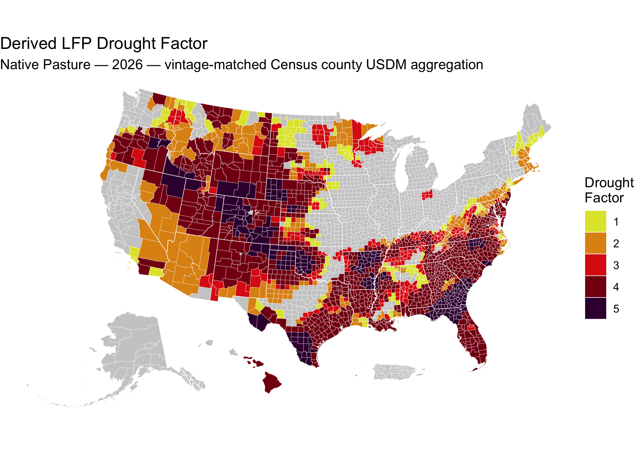
📍 Quick Start: Map LFP Eligibility in R
This README is rendered by the weekly build, so the example reads the
Parquet file that build just produced. To run it yourself, substitute
the published URL
https://data.sustainable-fsa.com/fsa-lfp-eligibility-derived/fsa-lfp-eligibility-derived.parquet
— arrow::read_parquet() takes it directly.
# Load required libraries
library(sf)
library(ggplot2) # For plotting
library(tigris)  # For county boundaries
library(rmapshaper) # For innerlines function

## Get the derived eligibility data
lfp <- arrow::read_parquet("fsa-lfp-eligibility-derived.parquet")

counties <-
  tigris::counties(cb = TRUE,
                   resolution = "5m",
                   progress_bar = FALSE) |>
  dplyr::filter(
    !(STATE_NAME %in% c("Guam",
                        "American Samoa",
                        "United States Virgin Islands",
                        "Commonwealth of the Northern Mariana Islands"))
  ) |>
  sf::st_cast("POLYGON", warn = FALSE, do_split = TRUE) |>
  tigris::shift_geometry() |>
  dplyr::group_by(STATEFP, COUNTYFP) |>
  dplyr::summarise(.groups = "drop") |>
  sf::st_cast("MULTIPOLYGON")

## The 2026 Native Pasture drought factor on Census counties, using the boundary
## vintage current as of each USDM week. Reduced to Census county grain by taking
## the highest factor across the FSA offices that share a county -- that `max()`
## is one of the reduction rules described above.
lfp_counties <-
  lfp |>
  dplyr::filter(`Pasture Type` == "Native Pasture",
                `Program Year` == 2026,
                source == "usdm-counties") |>
  dplyr::group_by(id = FIPS) |>
  dplyr::summarise(`Drought Factor` = max(`Drought Factor`),
                   .groups = "drop") |>
  dplyr::mutate(
    `Drought Factor` = factor(`Drought Factor`,
                              levels = 1:5,
                              ordered = TRUE)
  ) |>
  dplyr::left_join(
    counties |>
      dplyr::transmute(id = paste0(STATEFP, COUNTYFP))
    ) |>
  sf::st_as_sf()

# Plot the map
ggplot(counties) +
  geom_sf(data = sf::st_union(counties),
          fill = "grey80",
          color = NA) +
  geom_sf(data = lfp_counties,
          aes(fill = `Drought Factor`),
          color = NA,
          show.legend = TRUE) +
  geom_sf(data = rmapshaper::ms_innerlines(counties),
          fill = NA,
          color = "white",
          linewidth = 0.1) +
  geom_sf(data = counties |>
            dplyr::group_by(STATEFP) |>
            dplyr::summarise() |>
            rmapshaper::ms_innerlines(),
          fill = NA,
          color = "white",
          linewidth = 0.2) +
  # Use the same color scale used by the LFP
  # https://www.fsa.usda.gov/documents/native-pasture-2024-lfp-01-23-25
  scale_fill_manual(
    values = c("1" = "#E0E436",
               "2" = "#DF9114",
               "3" = "#DD2313",
               "4" = "#850014",
               "5" = "#3B003C"),
    drop = FALSE,
    name = "Drought\nFactor") +
  labs(title = "Derived LFP Drought Factor",
       subtitle = "Native Pasture — 2026 — vintage-matched Census county USDM aggregation") +
  theme_void()
🧭 Related archives
Three archives cover LFP county eligibility, at the same event grain and with the same event codes, so they can be compared directly:
- fsa-lfp-eligibility — FSA’s determinations as obtained by FOIA, program years 2008–2025
- fsa-lfp-eligibility-web — FSA’s determinations as published weekly on its maps page, 2008–present, including every superseded weekly version
- fsa-lfp-eligibility-derived — eligibility recomputed from the US Drought Monitor under four county aggregations
The FOIA archive is the richer record for closed program years: it includes fire eligibility and payment factors the web tables omit. The web archive covers the current program year and, for 2008–2011, carries per-tier dates the FOIA response omitted. The derived archive is not a record of FSA’s determinations.
📝 Citation
If you use this data in published work, please cite:
Bocinsky, R. Kyle. Livestock Forage Disaster Program Eligibility, 2008–present: Eligibility Derived across Authoritative County Boundary Datasets. Montana Climate Office, University of Montana. Sustainable FSA project. Accessed YYYY-MM-DD. https://data.sustainable-fsa.com/fsa-lfp-eligibility-derived/
Machine-readable metadata are in CITATION.cff;
GitHub’s Cite this repository button (top right of the repo page)
renders it as APA or BibTeX.
The underlying data this archive reads should be cited separately — the Normal Grazing Periods and the USDM county aggregations each have their own archive and citation.
Acknowledgment: This work is part of the Enhancing Sustainable Disaster Relief in FSA Programs project, supported by the USDA Office of the Chief Economist, Office of Energy and Environmental Policy, and the USDA Climate Hubs.
📄 License
- Raw USDM data (NDMC) and raw FOIA data (USDA): Public Domain (17 USC § 105)
- Processed data & scripts: © R. Kyle Bocinsky, released under CC0 and MIT License as applicable
⚠️ Disclaimer
This dataset is archived for research and educational use only. It is a derived, not a record of USDA’s determinations, and it is not evidence of any producer’s eligibility for any program. It may not reflect current USDA administrative boundaries or official LFP policy. Always consult your local FSA office for the latest program guidance.
To locate your nearest USDA Farm Service Agency office, use the USDA Service Center Locator:
👏 Acknowledgment
This project is part of:
Enhancing Sustainable Disaster Relief in FSA
Programs
Supported by USDA OCE/OEEP and USDA Climate Hubs
Prepared by the Montana Climate Office
✉️ Contact
R. Kyle Bocinsky
Director of Climate Extension
Montana Climate Office
📧 kyle.bocinsky@umontana.edu
🌐 https://climate.umt.edu